SEA LEVELS
Sea levels have been rising since the maximum of the last ice 20,000 years ago. The rate of sea level rise is regarded as an indicator of climate change.
The sea level rises for two reasons: thermal expansion of sea water as it heats and the melting of ice on land.
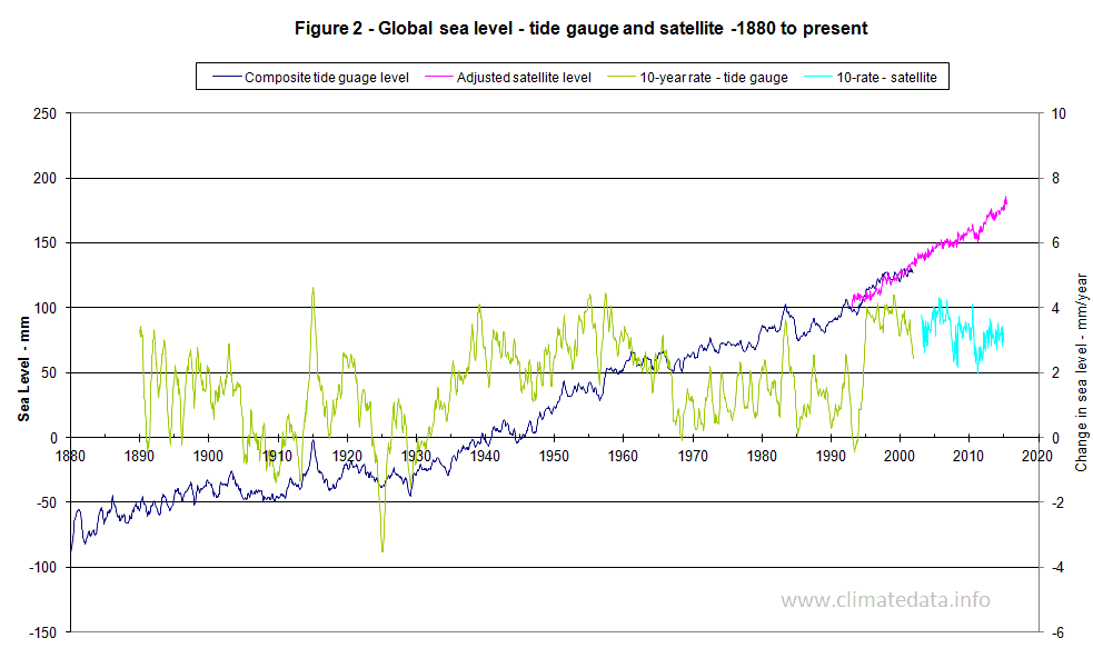
Figure 2 shows a composite record from the two tide gauge estimates and satellite based data from the TOPEX/JASON satellite system. To harmonise the two data sets the satellite data were adjusted to give the same average for the period of overlap. The graph also shows the rate of rise per decade. This was based on subtracting the difference in level for pairs of months 10 years apart. Over the last century or so the rate of rise has fluctuated from -2 mm/year up to 4 mm/year. The increase since 1880 has been around 250 mm.
Further data is available for the sea level values for the Maldives and also 12 Pacific Islands.
The sea level rises for two reasons: thermal expansion of sea water as it heats and the melting of ice on land.
Long Term Sea Level Change
During an ice age, ice covers are large areas around both poles. The amount of water in the ice caps is such that sea levels are markedly reduced. Levels 20,000 years ago, at the maximum of the last ice age, were 140 m lower than they are today. Until about 7,000 years ago the rate of rise was about 5 mm/year. Since then rate of rise has averaged 1 mm/year.Estimation of Sea Level Change
Global sea levels have traditionally been estimated from tide gauges. As can be imagined they show fluctuations of several meters due to tide and wave action. Identifying sea level changes of a few millimetres a year against this background “noise” is problematic. Since 1993, data are available from satellites. There are two other factors which add to the difficulty of estimating changes in sea level. The first is the way the earth has reacted to the melting of the ice caps. Where major ice melt has taken place, in northern Europe and North America for example, land levels have risen; the post glacial rebound (PGR). Conversely where sea levels have risen and encroached on previously dry areas, land levels have fallen; glacial isostatic adjustment (GIA). (Some sources use the two terms interchangeably) These changes typically average around 0.4 mm/year but can be higher in some locations. The second factor is the influence of atmospheric pressure. The changes in pressure can be seasonal and modify levels by 1 metre; often an allowance is made for these pressure differences by applying what is called “an inverted barometer.” As can be seen the adjustments to be made to sea level are of a similar order of magnitude to changes in sea level itself. It is generally considered that the rate of change of sea level cannot be accurately estimated for periods of less than 10 years.Sea Level Change
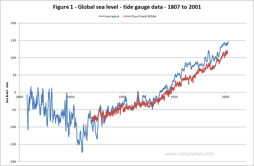
Figure 1 shows the sea level changes from 1807 to 2001 using two estimates based on tide gauges (Jevrejeva et al and Church at al). There is broad agreement between the two estimates. The Jevrejeva record show that sea levels fell for the first half of the 19th century. This suggests that the low temperatures recorded in Europe in this period may have been representative of global temperatures. It also follows the Dalton minimum of sunspot activity.Figure 2 shows a composite record from the two tide gauge estimates and satellite based data from the TOPEX/JASON satellite system. To harmonise the two data sets the satellite data were adjusted to give the same average for the period of overlap. The graph also shows the rate of rise per decade. This was based on subtracting the difference in level for pairs of months 10 years apart. Over the last century or so the rate of rise has fluctuated from -2 mm/year up to 4 mm/year. The increase since 1880 has been around 250 mm.
Further data is available for the sea level values for the Maldives and also 12 Pacific Islands.
http://www.climatedata.info/